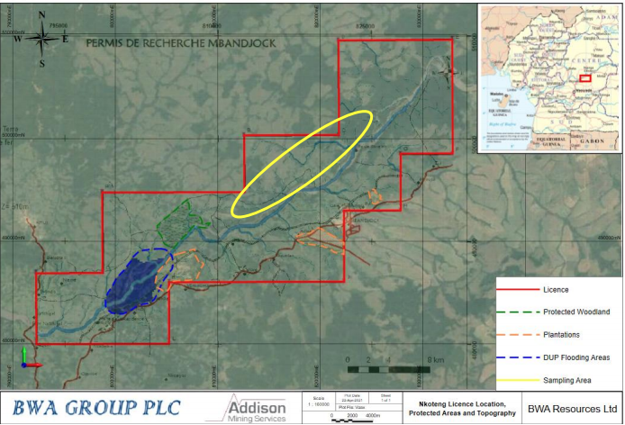
BWA Reports Positive Sampling Results from Cameroon.


has released positive sampling results from its recent surface sampling programme at its 90% owned Nkoteng rutile sands project located in Central Cameroon. (See Fig 1). The positive results were gathered as part of its reconnaissance surface exploration pit and auger sampling programme and reported in accordance with JORC (2012).
Figure 1: Nkoteng License area in Cameroon

Nkoteng is located within the Yaoundé Domain of the Pan African Belt, a large nappe unit that has been thrusted southward onto the Congo Craton and is characterised by low-grade to high-grade garnet bearing metamorphosed schists, gneiss and orthogneisses (See Fig 2)
Figure 2: Location of Nkoteng within the Pan African Belt
The Sampling Programme
The programme targeted the central sector of the licence and has identified an area of alluvial HMS mineralisation related to the extensive Sanaga river system and associated floodplains.
The sampling programme comprised 15 hand excavated exploration pits and 38 auger holes for a total of 169.1 m and 90 samples (See Fig 3).
Three grab samples were also taken as part of the reconnaissance programme.
Results from samples confirm the area has anomalous titanium (Rutile-Ilmenite), zirconium (Zircon) and aluminium (Kyanite) with samples reporting up to 2.38% TiO2, 0.29% Zr and 25.6% Al2O3
The combined areas tested equate to approximately 39 km2 of the Sanaga river floodplain consisting of the northern (7 km2), central (17 km2) and southern areas (15 km2), which represents around 16 km of strike or 40% of the BWA available river system excluding restricted areas in the southern part of the licence, where there is a DUP (Décret d'utilité publique) protected environmental area that encompasses approximately 10 km of the active river and prevents exploration and mining.
Figure 3: Sampling Programme 15 hand excavated pits
Sampling Results
Results from samples confirm the area has anomalous titanium (Rutile-Ilmenite), zirconium (Zircon) and aluminium (Kyanite) with samples reporting up to 2.38% TiO2, 0.29% Zr and 25.6% Al2O3.
Of the 93 samples collected around the central Sanaga area within the Nkoteng license, 47 controlled interval samples in excess of 1% TiO2 with associated elevated Zr and Al2O3
The results of the programme are extremely encouraging as the basement geology and depositional environments are currently interpreted as being continuous over the available approximate 40 km of the Sanaga river within the current BWA landholding, excluding restricted areas. Positive results for TiO2, Al2O3 and Zr were from the three areas sampled, the north, central and south. The central area appears to be more positive than the northern and southern samples, but these extremities are still anomalous for HMS and show encouraging continuation of mineralisation over 15 km.
The central area was targeted more heavily after the presence of gravel and encouraging HMS mineralisation at the bottom of the hole NKO_002 was observed and suggests that the Sanaga River was deeper at this location at some point in its history and is likely either an abandoned channel or a cut meander. BWA are extremely encouraged by the grade and extent of all the target minerals and are planning follow up work, to be conducted shortly.
Figure 4: Sampling Results
Richard Battersby, Non-executive Chairman of BWA, commented: “We regard these initial pit and auger results for the Nkoteng licence as extremely encouraging and supportive of BWA’s long-held view of the prospectivity for significant rutile and zircon mineralisation in the Sanaga river system. These results demonstrate the presence of titanium, zircon and aluminium at grades and intervals of potential economic interest within interpreted extensive depositional environments along the prospective Sanaga river system contained within our licence area.
Geology and Geological Interpretation
The prospective Sanaga river is the main river which runs through the BWA licence area and accommodates approximately 50 km of the river floodplain system and associated tributaries, and an even larger paleo-floodplain area, observed in satellite imagery. This interpreted paleo-floodplain is likely to be a significant target for exploration and covers the length of the river with an initial interpreted width of up to 3 km.
The geological sequence generally consists of 0.3 m to 4.3 m with an average of 2.4 m of clay cover from surface. This clay cover is laid on top of detrital deposits consisting of sands and gravels with an average thickness of 0.45 m. In places it lies directly on the bedrock. The limited sampling for plastic clays also suggests that it contains HMS mineralisation, which increases the thickness of the mineralised zones.
The Nkoteng deposit is likely to be a trap placer (native) deposit. The entire stratigraphic column of the Sanaga alluvial deposits is considered potentially mineralised.
Nkoteng is located within the Yaoundé Domain of the Pan African Belt, a large nappe unit that has been thrusted southward onto the Congo Craton and is characterised by low-grade to high-grade garnet bearing metamorphosed schists, gneiss and orthogneisses.
Heavy mineral sands are loose aggregates of unlithified material containing combinations of minerals with a high specific gravity, generally above 4 g/cm3.
The heavy minerals at Nkoteng occur in a variety of igneous and metamorphic rocks, but because of their resistance to weathering and comparatively high specific gravity, they are found to accumulate in river channels.
The Nkoteng pit programme encountered distinctive alluvial basal sand and gravel units, with average thicknesses of some 2.4 m. Depths of up to 8 m have been stated in Archidona Minerales S.A (formally Cameroon Rutile) adjacent Nanga-Eboko (Lembe) licence, situated up-stream to the east along the Sanaga from Nkoteng.
Archidona Minerales and the BRGM have historically reported that the Sélé and Tédé rivers, within the Nanga-Eboko licence are estimated to contain approximately 723,000 tons* @ 1.1% TiO2 and 174,000 tons* @ 0.89% TiO2 respectively (BRGM RR-36134). Archidona are not carrying out any field work at this time.
The Nkoteng general area has been known for some historic small scale artisanal rutile mining. This historic work has been developed by Eramet to the south of the Nkoteng licence who are currently carrying out advanced exploration in the Akonolinga area and Archidona Minerals who hold the Nanga-Eboko licence, immediately adjacent to the east of BWAs Nkoteng licence.
Eramet are currently carrying out exploration work along the Yo and Djaa rivers in the Akonolinga area. The respective widths of the Yo and Djaa rivers are 400 m and 300 m with the average thickness of prospective alluvium of about 2.5 m.
Previous explorer, Cameroon Minerals reported historic resources for the Yo and Djaa rivers systems at approximately 0.64 Mt* @ 1.4% rutile (TiO2) and 1.32 Mt* @ 1.05% rutile (TiO2) for Indicated and Inferred classifications respectively.
Further afield, Sierra Rutile (subsidiary of Iluka Resources) HMS projects consist of a multi-mine operation located in the Bonthe and Moyamba districts, south west Sierra Leone. Sierra Rutile has an established operating history over more than 50 years and further mine life of at least 20 years, with plans to increase production from current levels of ~150ktpa of rutile.
Sierra Rutile is also associated to the Pan African Belt, a large nappe unit characterised by metamorphosed schists, gneiss and orthogneisses. Tertiary to Recent sediments, known as the Bullom Group, unconformably overlays the crystalline basement rocks. The Bullom Group comprises sediments recognised as having been deposited in alluvial, fluvial, coastal marine and estuarine environments. Rutile and other heavy minerals were liberated in response to the erosion of topographically elevated areas subsequently deposited in erosional valleys or as alluvial fans.
The Sierra Rutile properties have a mineral resource, reported in accordance with the JORC Code (2012) as of the 31st of December 2016 of 60 Mt* at @ 1.26% rutile, 0.12% ilmenite and 0.16% zircon (Measured); 538 Mt* at @ 1.02% rutile, 0.14% ilmenite and 0.07% zircon (Indicated); 122 Mt* at @ 1.06% rutile, 0.00% ilmenite and 0.01% zircon (Inferred) (http://www.sierra-rutile.com/).
Outlook
The programme has demonstrated that there is excellent potential for continuous MS mineralisation and deposit development within the area tested at sufficient levels to warrant further follow up systematic exploration. The company are processing the data and are still in the early stages of exploration and evaluation, understanding the distribution of mineralisation and related size fractions, but are very encouraged by the presence of elevated intervals of Rutile-Ilmenite, Zircon and Kyanite over continuous zones within an area considered prospective for heavy mineral sands, and that the first campaign in this area has returned such positive results to warrant further exploration.
BWA are planning immediate follow-up on these anomalous results with a view to extend and infill the sample area, as well as understand the relationships between the mineralisation and host strata and carry out additional sampling on the plastic clays. This work will provide a better indication of the HMS exploration potential within the licence and better focus intended follow up drill programmes.
Richard added “We are greatly encouraged by the grades encountered thus far, which compare favourably to those seen in alluvial HMS mining operations worldwide and the target deposit model. The Company has already initiated similar tests at our Dehane licence situated on the prospective Nyong river system, following on from positive results from surface grab sampling completed in 2020, as well as expanding the exploration work at Nkoteng. We become increasingly attracted by the outlook for our investment in Cameroon.”
View from Vox
Strong results from BWA with the Company already committed to following up these results with further systematic exploration and infill sampling. Further definition of the relationship between the mineralisation and host strata could be very interesting to investors in terms of the resource potential.
The shares have been boosted 126% following the sampling results with the shares now trading 0.6-0.8p in early morning markets.
Reasons to BWA
BWA Group Plc is a minerals exploration investment company, which has seven mineral exploration licenses in Canada and Cameroon at various stages of development from grass roots to advanced exploration and is quoted on London's AQSE Growth Market.
BWA currently has two Heavy Mineral Sands ("HMS") licences in Cameroon, both of which are at an early stage of exploration. The Nkoteng Licence covers an area of 497 km2, comprising part of the prospective Sanaga river system and is located 60 km to the north east of Yaoundé with easy transport links to the port of Douala. The Dehane Licence ("Dehane" or the "Dehane Project") is 132 km2 comprising part of the prospective Nyong river system estuary and is located 166 km to the west of the capital, Yaoundé and 70km from the deep seaport and industrial zone of Kribi.
In September 2019, BWA acquired the entire share capital of Kings of the North Corp, a company incorporated in Canada for a total of £4.66m, which owns several, principally gold, mining licenses in Quebec and Ontario. BWA announced the conditional disposal of the investment in Kings of the North on 24th August 2020.
Its 90%-owned subsidiary BWA Resources (UK), was awarded two mining exploration permits for rutile sands and related minerals in Cameroon in December 2019 and January 2020.
BWA holds mineral exploration licences in both Canada and Cameroon, including two heavy mineral sands ("HMS") licences in Cameroon which are both at an early stage of exploration.
The Dehane licence is located on the Western Cameroon Domain, which extends along the border between Nigeria and Cameroon. This domain consists of a series of medium-grade to high grade schists and gneisses of volcanic and volcano-sedimentary origin, intruded by later-stage granitoid complexes, the basement rocks are a source of heavy minerals.
Dehane has been known for some historic small scale artisanal historical rutile mining area. However, the extent of its exploitation has not translated to concentrated modern exploration.
Heavy mineral sands are loose aggregates of unlithified material containing combinations of minerals with a high specific gravity, generally above 4 g/cm . The heavy minerals at Dehane occur in a variety of igneous and metamorphic rocks, but because of their resistance to weathering and comparatively high specific gravity, they are found to accumulate in river channels
Disclaimer & Declaration of Interest
The information, investment views and recommendations in this article are provided for general information purposes only. Nothing in this article should be construed as a solicitation to buy or sell any financial product relating to any companies under discussion or to engage in or refrain from doing so or engaging in any other transaction. Any opinions or comments are made to the best of the knowledge and belief of the writer but no responsibility is accepted for actions based on such opinions or comments. Vox Markets may receive payment from companies mentioned for enhanced profiling or publication presence. The writer may or may not hold investments in the companies under discussion.